CENTRAL IOWA WEATHER MAPS

* indicates just an image is downloaded

Links updated on 2/15/2010

sunspots phase OFFICIAL TIMES FROM USNO

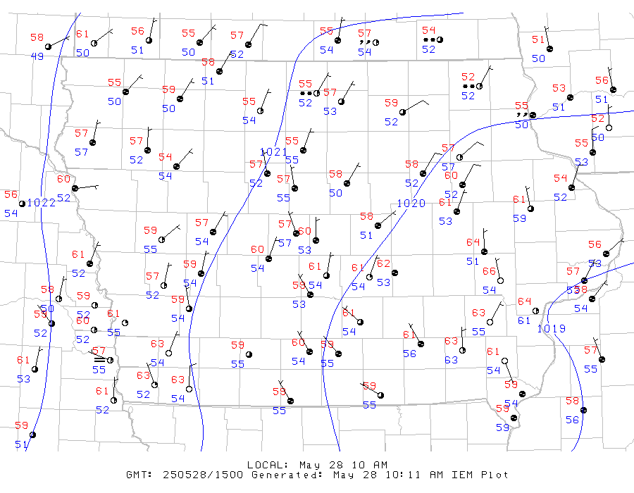
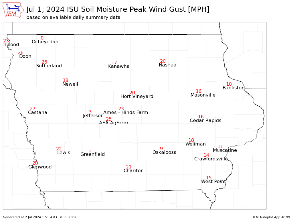
WARNING: These maps may or may not be accurate. The generators of these maps can not be held responsible for the validity of them. The writer of this website does not generate any of these, I have just collected them here for you. USE AT YOUR OWN RISK!!!
SOAPBOX: You know, I wish weather websites would bank off of Google's success. Slim lined sites that load quickly, are informative, and have reduced advertising. But, alas, weather sites are going the other way. KCCI's site is an example. Previous to their update, I could go to their page, have it load in OK speed, and have the forcast, warnings, and radar in one quick spot. Now they have some flashy thing that is very slow and you have to do multiple clicks to get the information. It's not just KCCI, or even just weather sites. There is so many bloated ad calls and unnecessary tracking on most sites these days. I go to weather sites to get information, not be entertained. GOSH!!!! It's why I have this site here.

RADAR

  • *Weather Underground radar animated

  • *AccuWeather Regional radar animated
  • *AccuWeather Iowa dopler

  • KCCI Interactive Radar
  • *KCCI Iowa dopler animated
  • *KCCI Central dopler animated
  • *KCCI Polk County dopler animated
  • *KCCI NE dopler
  • *KCCI SE dopler
  • *KCCI NW dopler
  • *KCCI SW dopler

  • WHO animated doplers

  • WOI Interactive NEXRAD
  • *WOI Iowa radar
  • *WOI Metro radar

  • NWS Interactive nexrad

  • *Weather Channel dopler
  • Weather Channel Interactive

  • *Intellicast regional radar loop
  • Intellicast Interactive maps

    SATELLITE

  • *AccuWeather clouds animated

  • *WHO clouds

  • *WOI sat-rad

  • *MyWeather clouds

  • NASA visible

  • Microsoft Research maps Des Moines aerial
  • Bing Des Moines aerial
  • Google Des Moines aerial

  • ALERTS

  • NOAA warnings/watches

  • *Iowa Telecom warnings/watches

  • IEM interactive map

  • *AccuWeather warnings key

    MISC. MONITORING

  • *WeatherBug regional lightning

  • *IEM road temps/conditions
  • *IEM metro road temps/conditions

  • Iowa DOT road conditions
  • DOT road construction
  • DOT station reports

  • Des Moines Pollen

  • *IEM Iowa Snow Depth
  • *IEM Mesonet loop
  • IEM River Levels
  • *IEM Solar Radiation
  • *IEM Wind Speeds Gusts

  • *Weather Underground Wind loop
  • Weather Underground Misc Maps via WHO

  • *Weather Channel US earthquakes

  • Government air quality
  • Army river levels
  • NOAA river levels

    METEOROLOGY

  • *Weather Channel map

  • *MyWeather map

  • WEATHER INFORMATION CENTERS

  • *NOAA weather story
  • NOAA Des Moines detail
  • NOAA weather center

  • Weather Hour by Hour
  • Weather Channel 10 day

  • KCCI 5 day
  • KCCI SchoolNet8
  • *KCCI Summary
  • KCCI weather closings

  • Intellicast 10 day

  • WHO 7 day
  • *WHO Summary

  • WOI 7 day
  • *WOI Summary

  • Weather Underground 5 day

  • AccuWeather 15 day

    SPACE

  • SpaceWeather auroras
  • *POES Auroral Activity
  • Geophysical Aurora predictor *N. America
  • SSDP Real Time Aurora

  • Heavens Above Iridium flares
  • NASA space craft tracker

  • Weather Underground sky

  • LIVE CAMS

    *KCCI SchoolNet8
    time lapse

  • DOT Des Moines I-235 cameras
  • IDOT road cams via IEM
  • LIVE CAMS

    *KCRG CityCam Network
    time lapse
    Weather Bug Cameras
    MarshalltownSioux City (E)
    BoxholmIndependence
    OkobojiStorm Lake
    CleghornHumeston
    Sioux City (N)

  • Corn Cam
  • LIVE CAMS

  • ISU, West Lawn

  • *Boone, Scenic Valley RR

  • *Des Moines, downtown
  • *Des Moines, west
  • *Des Moines, east
  • *Des Moines, Airport

  • *Iowa City, UI

  • *Mason City, NIACC

  • Scott County cams
  • Quad Cities, dualcam
  • Lock and Dam 15 Eagle Cam

  • *Okoboji, Lake Okoboji


  • Troy's Webpages =